(click to view full)
NATO’s Muli-sensor Aerospace-Ground Joint ISR Interoperability Coalition (MAJIIC) project aimed to help participating nations share imaging and radar data from their planes and UAVs, even if their individual platforms were not designed for that kind of compatibility. MAJIIC ran from April 2005 through March 2009, and showed results in exercises and in Afghanistan, where participating countries could share full motion UAV videos. Now, NATO is embarking on a 5-year, EUR 100 million second phase, called MAJIIC 2 (Multi-intelligence All-source Joint ISR Interoperability Coalition).
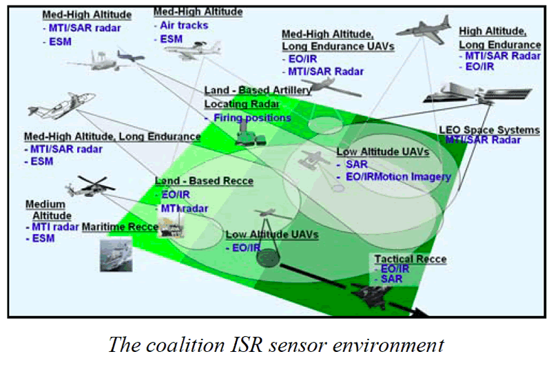
While the name behind the original acronym suggests a focus on aerospace platforms like UAVs, the project aims to handle any sensor platform on ground, sea, or air. That includes SAR/GMTI radars, day/night cameras, and even sensors like ESM radar finders and artillery locating radars.
Herat, Afghanistan
(click to view full)
MAJIIC works at operational, architectural, and technical standards levels. The idea is to use common interfaces for data formats and exchange mechanisms, keeping modifications to any given system very minor. The idea is that systems provide data to another component, and that component is where the connection happens to the common network structure, designed to use any network type or bandwidth. The data itself is exchanged outside the boundaries of any collecting systems.
Standards used are based on STANAG 4545 for still EO/IR/SAR images, STANAG 4609 for moving EO/IR, STANAG 4607 for moving GMTI radar data, and STANAG 5516 for track and track management messages.
The original MAJIIC project had 9 participating countries: Britain, Canada, France, Germany, Italy, Netherlands, Norway, Spain, and the USA. All are back on board for MAJIC 2, which was formally launched in February 2011 during a Rome meeting, and formally briefed to the NATO armaments and C3 community on Feb 21/11. The goal is to develop MAJIIC’s technology further, and make it applicable to more platforms and situations.
The project will also look to sharing and leveraging military assets – such as UAV imagery – in support of civilian authorities in crisis management and other roles such as border monitoring. To some extent, Afghanistan itself is serving as a trial of sorts, with UAV sensors collecting farming-related information that’s relevant to Provincial Reconstruction Teams, as well as tactical intelligence.
The 9 nations have contracted technical management to NATO’s NC3A (NATO Consultation, Command and Control agency). Technical work has already begun, and major exercises are scheduled for 2012. NATO release.